tecznotes
Michal Migurski's notebook, listening post, and soapbox. Subscribe to ![]() this blog.
Check out the rest of my site as well.
this blog.
Check out the rest of my site as well.
Jul 14, 2008 7:32pm
flea market mapping II: revenge of big oil
I've been poking at this historical tileset of Oakland lately. Last time, I posted slippy maps of Oakland in 1877, 1912, and the 1950s. I recently acquired a 1936 Shell map of the bay area that filled in a time period I was interested, the pre-war years when the Bay Area started to make the transition to an automobile society but hadn't yet been experienced the military base explosion of World War II.
Here's the thing, check the new 1936 layer:
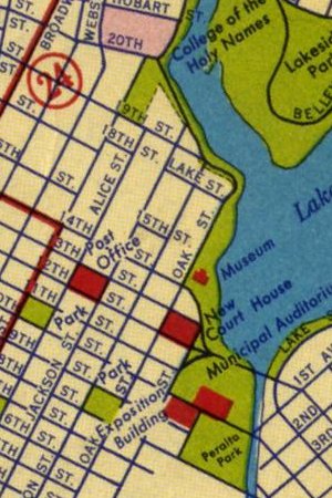
A few things I'm finding interesting about this new map:
- The visual treatment completely changes from the 1912 layer, starting to seem modern and borderline cartoonish.
- The progressive infill of Middle Harbor (just south of the Bay Bridge) visible over the years.
- The differences in highlighted driving routes between the 1930s and the 1950s, in particular the introduction of Macarthur Boulevard and West Grand Avenue.
- Still not a lot of trains shown on the second driving map.
- The Bay Bridge construction is apparently still underway, it opened in November 1936.
I'm starting to get better at quickly processing these layers from scanned images. The new one is a bit blurrier than I'd like, possibly due to the crappy Epson scanner I'm using here. Anyone within biking distance of Oakland or SF have a better scanner I can use to re-do the driving maps?
The next layer I want to get is something from the 1970s, maybe the 1980s - I'm keen to show the pre-Earthquake raised freeway structures that were ramrodded through West Oakland at the time.
subscribe to ![]() this site.
|
contact Michal Migurski
this site.
|
contact Michal Migurski
Comments (6)
Wow university ave used to be a 3.5 mile pier with a ferry at the end. http://en.wikipedia.org/wiki/Berkeley_Pier
Posted by Ryan on Monday, July 14 2008 9:12pm UTC
Yeah, it's interesting how there were all these long, spindly tendrils of rail and road reaching across the bay. The Oakland ones mostly got filled in, the Berkeley one was left to fall apart.
Posted by Michal Migurski on Monday, July 14 2008 11:13pm UTC
I love this idea of historical (or otherwise) maps combined with modern map providers! I intend to do the same thing with my volunteer historical/genealogical sites but have been attracted to--and playing with--Modest Maps. I wonder why you used OpenLayers rather than Modest Maps? It seems like the same method for reprojected historical map tiles could be used in Modest Maps... and then you'd get the beautiful added benefits. I'd be ecstatic if you, or anyone, provide a service to help create a properly projected tile-set based upon a scanned paper map. I'd be using it constantly! Steve, near Santa Cruz, Ca
Posted by Steve Williams on Thursday, September 25 2008 10:04pm UTC
Steve - I went with OpenLayers mostly just to give it a test drive, I hadn't used it before and wanted to see how easy it was to do a basic tiled map. I've been exploring the idea of making this into a service, and some of the pieces are starting to fall into place. The trick will be gracefully handling a potential upsurge in popularity, and designing the UI for adding markers. Really none of the components are difficult in isolation. Send me a mail so I remember to let you know if/when it's up for testing!
Posted by Michal Migurski on Thursday, September 25 2008 10:24pm UTC
Michal, I have no doubt of an upsurge in popularity or maybe that's just my predilection. However, Google seems to think this is a nice idea. New to the mappy app world, I just discovered Google Earth and Google Maps historical map overlays (see http://rumsey.geogarage.com/gmaps.html for instance) Wow... beauty, but a bit wanky in the UI. Markers: I wonder if it would be worth predicting the number of recommended markers required, based upon historical map cartography of a given time period? I'm sure the state-of-the-art in cartography increased as time went by, thus potentially requiring fewer markers... just a though. I'll send you an email. Would love to test whenever you are ready! Steve
Posted by Steve Williams on Wednesday, October 1 2008 12:44am UTC
Mike, Found West Oakland maps here, http://sunsite.berkeley.edu/histopo/, for 1949 1959 1968 1973 1980 1993 I had a look at the 1980 and it seems it might be detailed enough for your purposes.
Posted by Steve Williams on Thursday, October 2 2008 9:44pm UTC
Sorry, no new comments on old posts.