tecznotes
Michal Migurski's notebook, listening post, and soapbox. Subscribe to ![]() this blog.
Check out the rest of my site as well.
this blog.
Check out the rest of my site as well.
Oct 29, 2012 7:15am
the city from the valley: shuttle project for zero1
Last weekend, I participating in a panel on data and citizen sensors for the Urban Prototyping Festival. Our moderator was Peter Hirshberg, with co-panelists Sha Hwang, Genevieve Hoffman, Shannon Spanhake and Jeff Risom:
Urban Insights: Learning about Cities from Data & Citizen Sensors. Collection and visualization of urban data have quickly become powerful tools for municipal governance. Citizens now have the capacity to act as sensors, data analysts, information designers, or all of the above to help cities better understand themselves. This panel will focus on the evolving role of open data and its applications to the public sector.
In thinking about how to talk about data collection, I wanted to highlight a recent project that we at Stamen did for the Zero1 festival in San Jose, The City from the Valley: “An alternate transportation network of private buses—fully equipped with wifi—thus threads daily through San Francisco, picking up workers at unmarked bus stops (though many coexist in digital space), carrying them southward via the commuter lanes of the 101 and 280 freeways, and eventually delivers them to their campuses.”
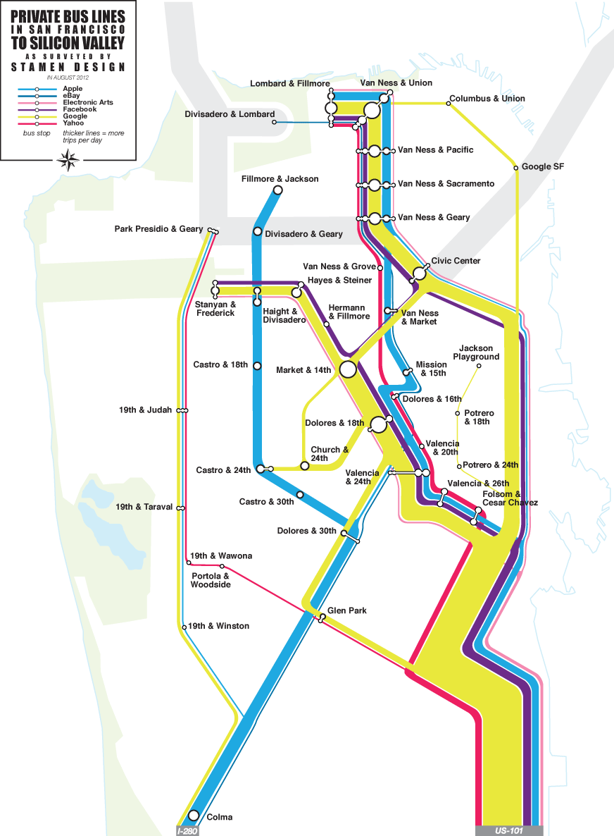
I’ve been fascinated by these buses for a few years now, first realizing the extent of the network over periodic Mission breakfast with Aaron. We’d drink our coffee and watch one after another after another gleaming white shuttle bus make its way up Valencia. I’d hear from friends about how the presence of the shuttles was driving SF real estate prices, and as a longtime Mission district weekday occupant the change in the local business ecology is unmissable.
The results of our observations suggest that this network of private shuttles carries about 1/3rd of Caltrain’s ridership every day, a huge number. I’m not sure myself of the best way to look at it. It’s clearly better to have people on transit instead of personal cars, but have we accidentally turned San Francisco into a bedroom community for the south bay instead?
According to a survey by the San Francisco County Transportation Authority, 80 percent of people riding the shuttles said they would be driving to work or otherwise wouldn't be able to live in San Francisco if they couldn't get the company-sponsored rides to work. —SF Supervisor Proposes Strict Regulations For Corporate Shuttles.
What of the Mission district, whose transformation into an artisinal brunch wonderland I’ve found aesthetically challenging? Maybe more significantly, what of the private perks offered by valley companies, of which private transport is just one? I think Google, Facebook, Apple and others have all done their own math and determined that it’s advantageous to move, feed, clothe, and generally coddle your workforce. This math scales a lot more than is obvious, and as a country we should be looking at things like the Affordable Care Act in a more favorable light, perhaps asking companies who need to move employees up and down the peninsula to pay more into Caltrain instead of running their own fleets. Election time is near, and even though my mind is made up the public vs. private debate in this country remains wide open. Am I comfortable with a Bay Area where the best-paid workers are also subject to a distorted view of reality, having their most basic needs passively met while those not lucky enough to work in the search ad mines have to seek out everything for themselves? Privilege is driving a smooth road and not even knowing it.
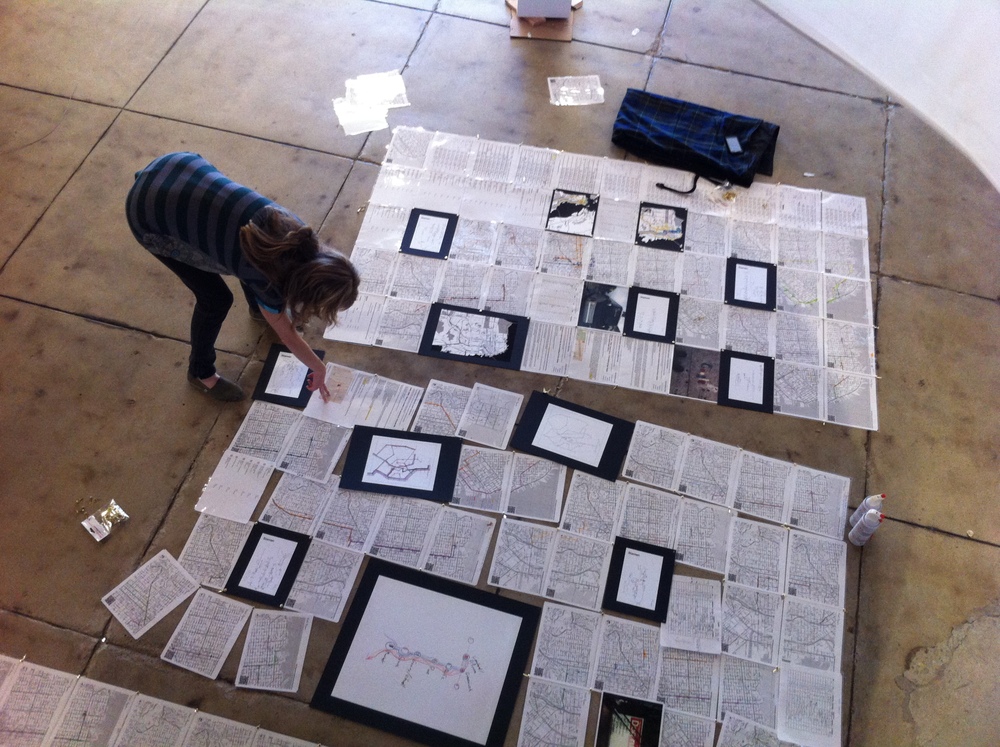
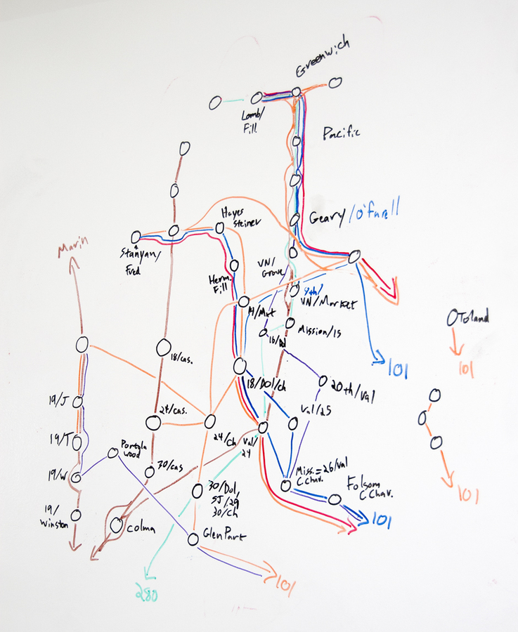
This fascination, by the way, is my total contribution to the project—once we all decided that the buses were worth exploring and after Eric, George and I had spent a morning counting them from the corner of 18th & Dolores to make sure we weren’t crazy, the gears of the studio kicked in and the project was born. Nathaniel and Julie worked with local couriers to track sample routes, and we used Field Papers to note passenger counts and stops. Zach looked at Foursquare checkins for clues. Nathaniel and Zach created the flow map above to illustrate our guesses at ridership and routes, and the whole thing went up in San Jose last month:
subscribe to ![]() this site.
|
contact Michal Migurski
this site.
|
contact Michal Migurski