tecznotes
Michal Migurski's notebook, listening post, and soapbox. Subscribe to ![]() this blog.
Check out the rest of my site as well.
this blog.
Check out the rest of my site as well.
Jun 22, 2009 6:00am
walking papers: end of week two
Right, so two weeks ago I pushed Walking Papers out of the nest, and it seems to have avoided the ground so far. This is a progress report.
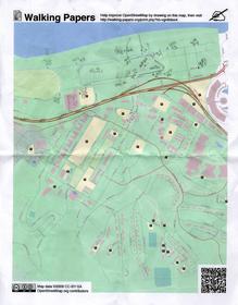
The reason I chose June 4th to make it live was the OpenStreetMap mapping party on June 6th, up in the Presidio Sports Basement store "big room". The event was the first public use of Walking Papers, and we presented it as a basic alternative to the usual GPS method of collecting map data. Several attendees jumped in, and we got a few excellent submissions including a survey of the marshy land east of Crissy Field and absurdly high detail of businesses along Chestnut St. These two scans were such a thrill: the technology worked and we got legitimately street-level data from enthusiastic participants!
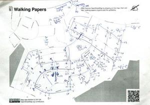
The most common piece of feedback I saw from users was to allow for landscape orientation in scans, so I added that feature this weekend. It's now possible to print maps in either landscape or portrait orientation, and the image recognition code distinguishes between the two based on aspect ratio. Users immediately started using the new orientation, including one German collecting house numbers:
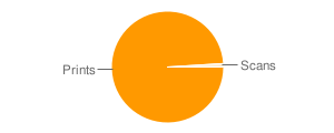
Generally speaking, we are seeing loads of prints and not very many scans. It's incredibly easy to hit the "make" button on the front page, less so to actually collect some useful information, so I'm not surprised by the disparity. I am looking forward to seeing more activity though, starting with a scheduled mapping party on June 27th and 28th at RPS.
We've seen some very welcome feedback as well.
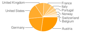
Austria's ORF Futurezone published an article devoted solely to Walking Papers on the 10th, which explains the disproportionate presence of many Austrian prints and resulted in a huge traffic bump.
Stefan Knecht of Germany's United Maps said the project was "just lovely", which was very nice to hear from someone whose work is so vital and excellent for online mapping:
Despite or even because of this "post-digital, medieval technology"- it's simply lovely. The reduce-to-the-max, crispy clear website is why I deeply adore Stamen for.
OpenStreetMap superhero Andy Allan pointed out that "even if you don't want to scan back in, it's actually a good interface for just printing maps for annotation."
Jason Kottke also sent some link love our way, in a post also highlighting The Incidental, the post-digital newspaper project Schulze and Webb (and Jones and Davies) at Milan's Salone di Mobile.
So that, in a nutshell, is what is happening with the project. It's nicely steaming along with regular prints, we're starting to see scans from users, we're playing with some ideas on how to more effectively foreground the idea of annotations and scanning on the site, the code continues to be freely available on Github, and I'm actively trying to boost real on-the-ground use of the system for actual mapping.


Comments
Sorry, no new comments on old posts.