tecznotes
Michal Migurski's notebook, listening post, and soapbox. Subscribe to ![]() this blog.
Check out the rest of my site as well.
this blog.
Check out the rest of my site as well.
Jun 2, 2009 11:17pm
oakland crime maps XII: the pie of time
We just made a substantial change to Oakland Crimespotting that addresses two big ideas: Big Time and Little Time.
Big Time is about history and trends, and you can see it in the newly-opened archives that offer links deep into the past of our crime database, from our first launch of the site in 2007, such as the assassination of Chauncey Bailey that first spurred us to release the project after I'd been personally collecting data for most of Spring and Summer 2007.
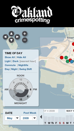
Little time is about the hours of the day, and the possibility of seeing neighborhood crime activity on a micro scale: your commute, your evening stroll with the dog, your morning run. The navigation concept we developed to support this is something we've been jokingly calling the "time pie", and it looks like this:
There's more about this on the Crimespotting blog, I encourage you to check it out.
subscribe to ![]() this site.
|
contact Michal Migurski
this site.
|
contact Michal Migurski
Comments (1)
Mike, I love the updates to the site. You are a clever bunch. The map styling and tools for viewing data over time are just great. Stamen make the rest of us not feel worthy :-) -Matt
Posted by Matt Sheehan on Tuesday, June 9 2009 8:21pm UTC
Sorry, no new comments on old posts.