tecznotes
Michal Migurski's notebook, listening post, and soapbox. Subscribe to ![]() this blog.
Check out the rest of my site as well.
this blog.
Check out the rest of my site as well.
Oct 9, 2009 4:52am
the other shoe drops
Wow, check this out:

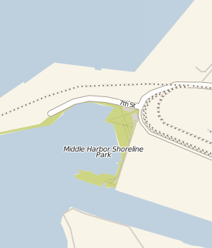
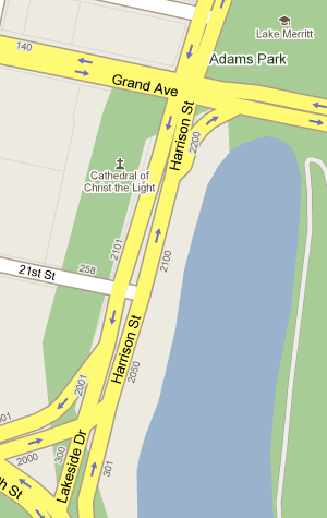
What's missing? "Map data copyright 2009 Google" - no TeleAtlas, NavTEQ, etc. Looks like all that street view driving finally paid off for something besides just photos of people picking their noses. I've long used the park above (Oakland's Middle Harbor Park) as a canary when checking up on major map provider's data. Most providers still use the coastline from before the army base moved out and the area was turned back into a wetland, and they also don't seem to be aware that this park exists. Google now has correct, new data overlaid on bad, out-of-date coastlines. You can see mismatches all over the place while this transitional period is underway.
This is how the area looks in reality:
Some of their data is now outrageously wrong:
I'm guessing this has something to do with the newly-hatched "report a problem" feature.
subscribe to ![]() this site.
|
contact Michal Migurski
this site.
|
contact Michal Migurski
Comments (2)
That's really interesting that they're rolling out their own maps. I wonder what sort of licenses they'll have? Maybe it can build on Openstreetmap?
Posted by Ross Hill on Saturday, October 10 2009 8:07am UTC
In my neck of the woods they've recently added parcel outlines to the default map view too.. not sure when exactly that happened.
Posted by tim stallmann on Saturday, October 24 2009 2:55am UTC
Sorry, no new comments on old posts.