tecznotes
Michal Migurski's notebook, listening post, and soapbox. Subscribe to ![]() this blog.
Check out the rest of my site as well.
this blog.
Check out the rest of my site as well.
Jul 19, 2011 6:08pm
help make pre-quake san francisco seeable
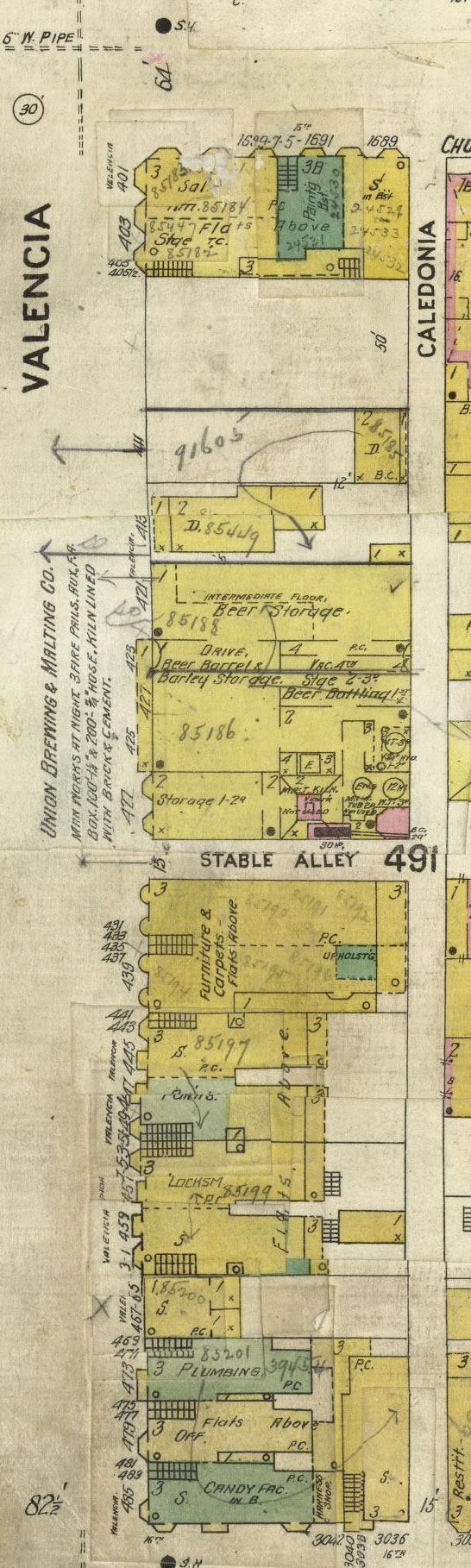
Take five minutes, and help place a few of these historic Sanborn maps of pre-earthquake San Francisco in their modern locations.


Maptcha is a thing I’ve been poking at since simultaneously finding the newly-rescanned 1905 San Francisco Sanborn Insurance Atlas via John “Burrito Justice” and being tipped off to Paper.js by Tom Carden. It’s a simple, minimal-code interface doing rough placements of historical maps on modern geography, and I’ve been getting completely amazing feedback from all the people who’ve checked out early versions (thanks Paul, Ryan, Cal, Boris, Heather, Tim, Matt, Schuyler, Ian, Tom, Eric and especially George).
Historical maps come with all the usual bibliographic context, but almost no geographic context: the point-to-point correspondences that make it possible to overlay them on modern maps. Tim, Schuyler and Shekhar have been doing some fantastic work in this area with map librarian Matt Knutzen at the New York Public Library on the NYPL Map Warper, something we were lucky enough to participate in last year. The release of the new Sanborn scans was an out-of-band inspiration along these same lines, and an opportunity to test some ideas that wouldn’t quite fit in the NYPL context.
- All of the Sanborn maps were at a similar scale and time period, which meant that we could ask people to look for cross-streets and be mostly confident that they still exist in a modern geocoder.
- There are a limited number (700 or so), making it possible to create a bounded task with a clear end-point. You can finish it, an important feature for crowdsourcing initiatives that might not have a realistic end.
- We know they’re roughly conformal despite the massive distortions in street width. Most of the time, it’s fine to make the north arrow point up and fiddle with the size to get a good-enough placement. This has the added bonus of not bringing GDALwarp into the mix—it’s made of Canadian geo-magic but imposes its own technical burdens.
A lot of these specific adaptations come from the Internet Archive’s George Oates, whose comments on my initial UI sketches helped greatly clarify some of the knowns we’ve got to hand in an atlas like this one.
I’m not sure what happens to the output data from this process. Certainly it will be made available in some open format that links geographic placement back to the original scans in the Rumsey collection. John’s been nudging me toward a second-pass, more advanced UI that can help refine all these rough placements to something more precise that can help answer real questions about San Francisco’s history immediately prior to the earthquake of 1906. I’ve long been curious about the train line that led to such a gorgeous stripe of scar tissue through the Mission, but what about all the extra information you can glean from business and construction listings as detailed as these?
Anyway, go give it a shot. Let’s see if we can’t get all these images placed.
subscribe to ![]() this site.
|
contact Michal Migurski
this site.
|
contact Michal Migurski