tecznotes
Michal Migurski's notebook, listening post, and soapbox. Subscribe to ![]() this blog.
Check out the rest of my site as well.
this blog.
Check out the rest of my site as well.
Jul 8, 2007 7:13pm
federal building
The new San Francisco federal building opens tomorrow, and there are a few details I like very much.
There's a sky garden on the 11th floor that overlooks SOMA, and is open to the public behind a security checkpoint:
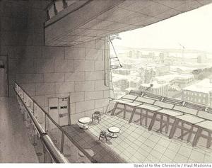
The exterior has a nice, jagged look to it, with lots of energy-saving skin features:

The elevators only stop on every 3rd floor, "to improve worker health by nudging them to use stairways - and also create crossroads where employees run onto each other, since each three-story segment includes a lobby with art and a viewing platform."
Jul 8, 2007 6:52pm
transit data
I've been collecting Bay Area public transit schedules from 511.org. I have loose plans for them, but it's going to be awhile before I get around to doing anything.
Meanwhile, here's the data: transit.db.gz, 6.4MB compressed SQLite 3 database, ~84MB uncompressed. Contains all stops for SF MUNI, AC Transit, AC Transit transbay service, and BART, in the following format:
CREATE TABLE stops (
    provider TEXT(16),
    route_name TEXT(8),
    schedule_name TEXT(32),
    stop_location TEXT(32),
    stop_time TEXT(16),

    schedule_url TEXT(128),
    PRIMARY KEY (provider, route_name,
                 schedule_name, stop_location,
                 stop_time)
);
subscribe to ![]() this site.
|
contact Michal Migurski
this site.
|
contact Michal Migurski