tecznotes
Michal Migurski's notebook, listening post, and soapbox. Subscribe to ![]() this blog.
Check out the rest of my site as well.
this blog.
Check out the rest of my site as well.
Mar 1, 2008 7:13pm
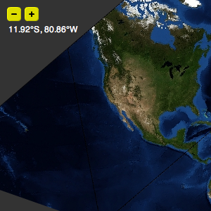
slippy faumaxion, take two
Two weeks ago, I posted the faumaxion slippy map, an interactive interpretation of Buckminster Fuller's Dymaxion World Map. I was curious to see whether the continuous re-orientation of the map would be jarring or confusing to users. Based on some helpful feedback, I've updated the map so that the dragging and rotation behaviors are separate. Instead of continuously re-orienting itself to face North for whatever point happens to be in the center of the map during a click-and-drag, a tiny compass rose shows which way the map will rotate itself once the mouse is released. This version feels calmer, and makes for a more predictable (and therefore better?) interaction:
subscribe to ![]() this site.
|
contact Michal Migurski
this site.
|
contact Michal Migurski
Comments (5)
Awesome. Much nicer and far less jarring. The compass rose is a really nice touch.
Posted by Sean on Saturday, March 1 2008 8:21pm UTC
Yeah, It's really much better. But still this map is not so accurate.
Posted by Oldi McGregor on Sunday, March 2 2008 3:33pm UTC
Accurate in what sense, Oldi?
Posted by Michal Migurski on Sunday, March 2 2008 5:31pm UTC
Mike, the fact that I am your biggest fan-boy aside... this makes me cry with joy. As I imagine it would make Fuller cry... since, as best as I can imagine, this *must* be the way he imagined navigating a dymaxion map. *must* be. ;)
Posted by Boris on Thursday, May 8 2008 8:11pm UTC
Thanks, Boris. =)
Posted by Michal Migurski on Friday, May 9 2008 5:50am UTC
Sorry, no new comments on old posts.