tecznotes
Michal Migurski's notebook, listening post, and soapbox. Subscribe to ![]() this blog.
Check out the rest of my site as well.
this blog.
Check out the rest of my site as well.
May 27, 2016 4:20pm
five-minute geocoder for openaddresses
The OpenAddresses project recently crossed 250 million worldwide address points with the addition of countrywide data for Australia. Data from OA is used by Mapbox, Consumer Finance Protection Bureau, and my company, Mapzen.
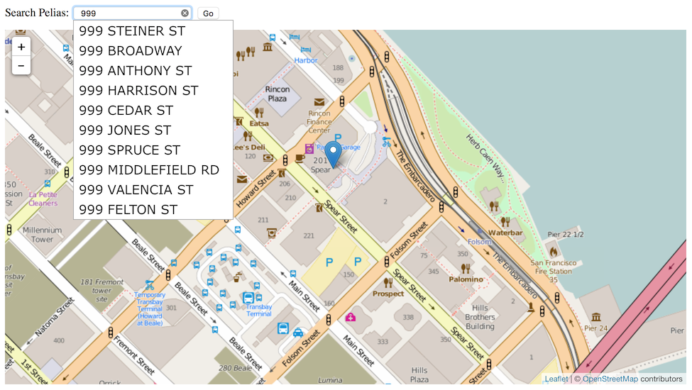
Now, you can use OpenAddresses in a high-quality geocoder yourself. “Geocoding” is the process of transforming input text, such as an address, or a name of a place to a geographic location on the earth's surface. Every time you search for a destination on your phone, you’re geocoding. Mapzen’s Search service uses an open source server we call Pelias, and if you’re using the popular Ubuntu Linux operating system, you can get it set up and serving addresses in just a few minutes.
Start with a clean server running a current version of Ubuntu LTS (long-term support); either 14.04 or 16.04 will work. Amazon has readymade Ubuntu images available on EC2, or a local copy running under Virtualbox will do for testing. Both the address import process and the Elasticsearch index are hungry for lots of memory, so pick a server with 4-8GB of memory to prevent failures.
Next, install the Pelias software using instructions from OpenAddresses:
# Tell Ubuntu where to find packages:
add-apt-repository ppa:openaddresses/geocoder -y
wget -qO - https://packages.elastic.co/GPG-KEY-elasticsearch | apt-key add -
echo "deb http://packages.elastic.co/elasticsearch/1.7/debian stable main" | tee -a /etc/apt/sources.list.d/elasticsearch-1.7.list

# Install Pelias and dependencies:
apt-get update && apt-get install pelias
This installs the Pelias geocoder, the OpenAddresses importer, a simple web-based map search interface, and the underlying Elasticsearch index.
After installation, you will need to import data. Visit results.openaddresses.io and pick a processed zip file to download. Start small with a city like Berkeley, CA to test the process. Download and unzip it in the directory `/var/tmp/openaddresses` where Pelias expects to find CSV files, then run `pelias-openaddresses-import` to index the data.
# Get a sample file of address data:
cd /var/tmp/openaddresses
curl -OL https://results.openaddresses.io/latest/run/us/ca/berkeley.zip
apt-get install unzip && unzip berkeley.zip

# Index the addresses:
pelias-openaddresses-import
That’s it!
Pelias includes many neat features out of the box, such as reverse geocoding and autocomplete. Read the docs on Github.
The Mapzen Search service includes some additional features that aren’t yet covered here. For example, to include administrative areas like cities or states in searches, it’s necessary to do an admin lookup while importing, and to include data from Who’s On First. I’m also interested to learn more about tuning Elasticsearch for smaller-sized servers with less system RAM. It should be possible to run a geocoder with 1-2GB of memory, and Elasticsearch may require adjustments to make this possible.
Links to more information about geocoding with OpenAddresses:
subscribe to ![]() this site.
|
contact Michal Migurski
this site.
|
contact Michal Migurski
Comments (3)
You should probably point out that many if the data sources in OpenAddresses have usage terms that need to be adhered to (for example the Australian GNAF address data, that is not actually "open") and that you will have to check them for licence compatibility with whatever you want to do with Pelias (and the same goes for WOF).
Posted by Simon Poole on Saturday, May 28 2016 10:22am UTC
Thanks, Simon!
Posted by Michal Migurski on Saturday, May 28 2016 4:13pm UTC
@Simon Poole- I'm interested in the restrictions you've been hitting with the Australian G-NAF address data. What part of them has been closed? I'm also using the dataset. My reading of the license is that it falls under Creative Commons 4, which is quite open, except with a clause preventing the data being used for sending spam snail mail: https://data.gov.au/dataset/geocoded-national-address-file-g-naf
Posted by Timothy Asquith on Friday, July 29 2016 12:37am UTC
Sorry, no new comments on old posts.