tecznotes
Michal Migurski's notebook, listening post, and soapbox. Subscribe to ![]() this blog.
Check out the rest of my site as well.
this blog.
Check out the rest of my site as well.
Feb 21, 2009 9:11pm
walking papers
It'd be awesome to be able to mark up OpenStreetMap on paper, while walking around, and still have the benefit of something that others could trace when you're done. Right now, you can throw a GPS in your bag and upload your traces for others to turn into actual road data. If you mark your notes on paper, though, it's a more tedious and lonely process to get that data into the system. For U.S. users, most of the raw roads are in the system already. Largely, what's left to be done consists of repositioning sloppy TIGER/Line roads and adding local detail like parks, schools, zoning, and soon addresses.
It'd be interesting for generated printouts of OSM data to encode enough source information to reconnect the scanned, scribbled-on result back with its point of origin, and use it as an online base map just like GPS traces and Yahoo aerial imagery.
A round trip through the papernet.
You might print out something that looks like this:
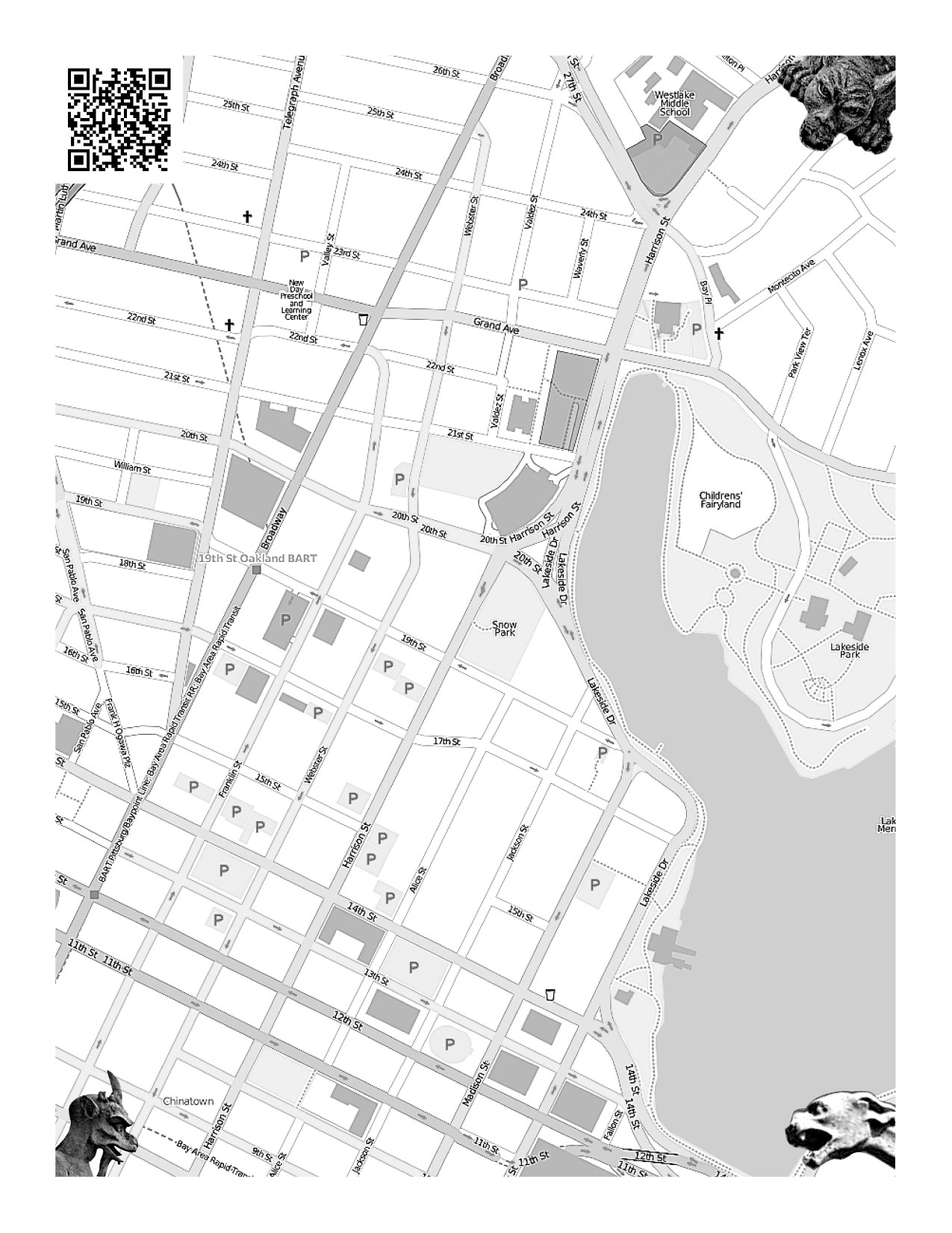
Maybe you'd print out a bunch of them, one for each neighborhood where you'll be walking and making local notes. You could fold them up and stick them in your pocket, photocopy them for other people, whatever. When you were done, you'd scan them in and a web service would figure out where the map came from, and make it available as a traceable base layer in Potlatch or JOSM.
How would the service know where the map came from?
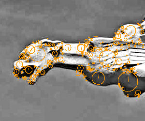
I've been looking at SIFT (Scale Invariant Feature Transform), a computer vision technique from UBC professor David Lowe. The idea behind SIFT is that it's possible to find "features" in an image and describe them independently of how big they are, or whether they've been rotated.
That's why the picture above has gargoyles in the corner.
They don't have to be gargoyles, they just have to look unique enough so you could tell them apart and recognize them separately from the map. SIFT can look at an original image, and find features in it like this:
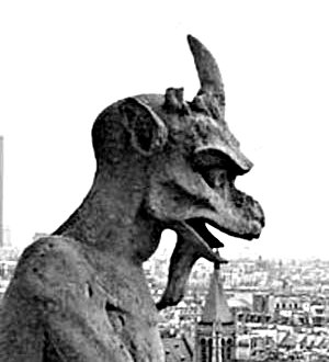
Check out the examples in Lowe's paper - he describes how detected features can be used to reconstruct entire objects.
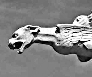
When a new scan is uploaded, SIFT finds all three gargoyles and then it knows exactly where the corners of the original image are, even if the person scanning it did it upside or sideways. It also knows where to find the QR barcode, the square thing that looks like static in the top left corner. Aaron's been thinking about QR codes for at least two years now, and he's got a simple decoder ring webserver that he banged together out of Java. The code would say something simple like "this map came from 37d48'N, 122d16'W", and that would be just about enough to make the scan into a base map that people could trace in an OpenStreetMap editor.

I got an implementation of SIFT from Andrea Vedaldi and Brian Fulkserson, computer vision students at UCLA. Their implementation makes .sift files like this one or this one. The code to read them isn't over complicated once you know what all the numbers mean - here's a short script, markup.py, that reads the first four values from each line of a .sift file (x, y, scale, rotation) and draws a little circle on the source image. Easy. The remaining 128 numbers on each line are like a signature, you can determine whether features from two different images are the same thing by looking at a simple squared, summed distance between the two.
Of course, it's also possible to forego SIFT entirely and pay random strangers a tenth of a penny to find gargoyles for you, or just have the people uploading the scanned maps point them out.
All that's left is to build the thing to do the stuff. =)
Feb 20, 2009 9:10am
speaking
I've got a bunch of things coming up where they put me in front of groups of people and I talk about stuff that I'm interested in (caution: mostly maps at the moment).
Stanford
Just about 11 hours from now, Tom and I will be doing this week's CS547 Human-Computer Interaction Seminar, thanks to an invitation from Jeff Heer.
E-Tech
On Monday, March 9, Shawn and I lead a three hour workshop at O'Reilly's annual E-Tech conference, entitled Maps From Scratch. We'll be doing a full-stack review of open source geographic software for data and design, along with a bit of Stamen's pushing of this particular envelope. We'll try not to mention the G-word if possible: DIY is the point here. Later that week, Eric will do an hour-long conference session on reaching through maps: similar topic area, but much more emphasis on Stamen's work and very little hands-on.
SXSW
I will celebrate the Ides of March in style with Andrew Turner, David Heyman, and Elizabeth Windram. The panel is Neocartography, and with luck 10:30am isn't crazy-early for conference goers. I've never been to Austin before, I hope the extremely tenuous-sounding hotel reservation I made through the SXSW web app doesn't leave me here begging for floor space in a week.
Where 2.0
I'm not sure if the schedule for this one is up yet, but it's in May and I'll be doing a one-person session on Flea Market Mapping. This will be a recap of the historical geography I've been exploring here on the blog, though May is a long time away and I might come up with some entirely new stuff to shoehorn into that title.
Feb 11, 2009 8:30am
sky movies
These are the two most affecting things I've seen in 2009.
The first is a video from James Leng, something I saw on Aaron's delicious feed:
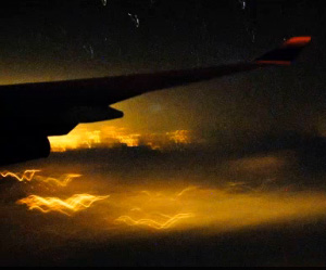
It's a timelapse video, recorded through the window of a half-empty flight traveling from Amsterdam to San Francisco. Turns out James is a friend of Sha's, and the video probably made its way over due to our work on Flickr Clock.
Here's what I had to say about it on the comments page:
The stars are actually the bit I find most interesting: seeing cities whoosh by like that, while the stars in the background remain mostly still reminds you who's really moving out there.
(that bit made it into the Guardian piece too)
The second came via Ori, and similarly records the night sky in motion:
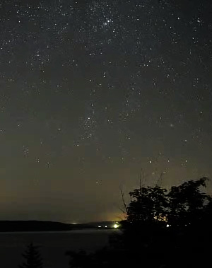
This one spans an entire night, somewhere on the coast of Maine, possibly by someone named Till Credner. The camera pans slowly from left to right, and on a few occasions planes stream by overhead. One of these planes might be James heading for California.
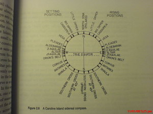
What ties these together is the visible relative motion of the stars. The earthbound video shows the entire dome of the sky turning slowly, while the airplane video shows the stars eerily standing still as the landscape moves below them. I'm reminded of Edwin Hutchins's explanation of the sidereal compass and alternative frames of reference in Cognition in the Wild:
Picture yourself on a Pulawat canoe at night. The weather is clear, the stars are out, but no land is in sight. The canoe is a familiar little world. Men sit about, talk, perhaps move around a little within their microcosm. On either side of the canoe, water streams past, a line of turbulence and bubbles merging into a wake and disappearing into the darkness. Overhead there are star, immovable, immutable. They swing in their paths across and out of the sky but invariably come up again in the same places. ... Everything passes by the little canoe - everything except the stars by night and the sun in the day.
I think if there's a broad class of subjective experience I find most addictive, it's the perspective shift connected to a sudden adjustment in point of view. The perception of the stars as motionless with the earth swinging through them can be just barely glimpsed in these short clips, similar to Patrick Farley's allegedly-Chillits-inspired 1998 strip Overheard At The Rave. One of my goals for 2009 is to vacation in a place with proper dark skies. Natural Bridges, or maybe the nearby Joshua Tree.
subscribe to ![]() this site.
|
contact Michal Migurski
this site.
|
contact Michal Migurski