tecznotes
Michal Migurski's notebook, listening post, and soapbox. Subscribe to ![]() this blog.
Check out the rest of my site as well.
this blog.
Check out the rest of my site as well.
Nov 18, 2008 9:29am
flea market mapping III: here come the freeways
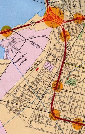
I've been expanding the georeferenced collection of Oakland maps that Gem and I started back in May. Recently, I purchased a 1967 Standard Oil map of Oakland for a few bucks from EBay. I was looking for late 1960's / early 1970's, because that's when the freeway structure here really started to take shape. Previously, we looked at a switch from rail to roads. Through the 50's and 60's, the switch was accelerated with the construction of massive highways through what had formerly been residential neighbhorhoods.
Particularly interesting is the Cypress Viaduct, a raised connection between highways 880, 580 and 80 running through West Oakland. When built, it was sharply criticized for splitting the neighborhood and further isolating it from downtown Oakland. The current site of the viaduct was where I made some of my first edits to OpenStreetMap. The structure was destroyed in the 1989 Loma Prieta earthquake shortly after my family moved to California, but on this map it's a fresh addition to the landscape:
The 19th anniversary of the quake was October 17th, one month ago.
The new 1967 map is a striking constrast to the previous 1952 map. The various freeways connected to Interstate 80 are one major difference, but the cartography is also a big contrast. This map is similar to the other Gousha-designed map from 1936 in its choice of bright colors, but it also features topographic shading up in the hills and orange highlights around freeway exits. A significant piece of infrastructure still under construction at this point is the 980 / 24 connector from downtown Oakland up into the hills toward the Caldecott Tunnel. The construction areas for the southern stretch are marked, while the northern route is still a whispy dotted line through miles of backyards.
subscribe to ![]() this site.
|
contact Michal Migurski
this site.
|
contact Michal Migurski